Learning How To Learn The Map effectively involves mastering spatial memory and mnemonic strategies. LEARNS.EDU.VN provides a structured approach to understanding geographic locations using memory techniques. Discover how to create associations, build Memory Palaces, and improve your geographical knowledge with our easy-to-follow guide, focusing on map memorization tips and efficient learning methods, ultimately enhancing your cognitive skills and geographic expertise.
1. Understanding the Importance of Learning Maps
Why bother learning maps? It’s more than just acing geography quizzes. Understanding maps enhances your spatial reasoning, improves your memory, and provides a deeper understanding of global events and cultures. According to a study by the National Research Council, spatial thinking is crucial for success in STEM fields. Learning maps isn’t just about memorization; it’s about developing critical thinking skills that are valuable in many aspects of life.
1.1. Benefits of Map Knowledge
- Improved Spatial Reasoning: Navigating the world becomes more intuitive.
- Enhanced Memory: Memory techniques used for maps can be applied to other areas.
- Deeper Understanding of Global Events: Knowing locations provides context for news and history.
- Cultural Awareness: Understanding geographic relationships fosters empathy and global citizenship.
- Career Advancement: Certain professions like logistics, travel, and international business require a solid understanding of maps.
1.2. Who Benefits from Learning Maps?
- Students (10-18): Excel in geography, history, and social studies.
- College Students (18-24): Enhance understanding in international relations, environmental science, and urban planning.
- Professionals (24-65+): Improve skills in logistics, travel, international business, and education.
- Teachers/Educators: Find new ways to teach geography to your students
2. Laying the Foundation: Spatial Awareness and Continents
Before diving into specific countries or regions, it’s essential to develop a strong sense of spatial awareness. This involves understanding the relative sizes and locations of continents, oceans, and major geographical features.
2.1. Visualizing Continents
Start by looking at world maps and mentally comparing the sizes of different continents. For example, Africa is much larger than many people realize when compared to Europe. Train your mind to rotate these spaces mentally.
2.2. Numbering the Continents
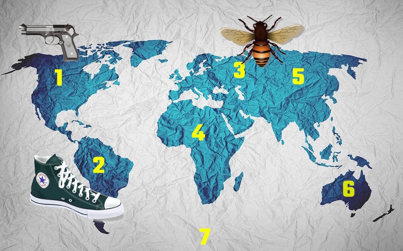
To aid memorization, assign a number to each continent. The most common model uses seven continents:
- North America
- South America
- Europe
- Africa
- Asia
- Australia
- Antarctica
You can create your own order, but consistency is key.
3. Mnemonic Techniques: Number Rhymes and Elaborative Encoding
Mnemonic techniques are powerful tools for turning abstract information into memorable images. Number rhymes, a variation of the pegword method, are particularly effective for learning the continents.
3.1. Understanding Number Rhymes
Assign a rhyming word to each number:
- One – gun
- Two – shoe
- Three – bee
- Four – door
- Five – hive
- Six – sticks
- Seven – heaven
3.2. Creating Memorable Associations
Now, combine the number rhyme with the continent:
- North America (One – Gun): Imagine a giant gun pointed towards North America, perhaps symbolizing the Second Amendment of the United States Constitution.
- South America (Two – Shoe): Picture a massive shoe dancing across South America, like the ruby slippers from The Wizard of Oz.
- Europe (Three – Bee): Envision a giant bee using the Eiffel Tower as a hive or pollinating famous European landmarks.
- Africa (Four – Door): Imagine Africa as a giant door made of ivory or another material associated with the region.
- Asia (Five – Hive): See the Forbidden City in Beijing as a bustling beehive.
- Australia (Six – Sticks): Picture a famous drummer energetically drumming on the landmass of Australia.
- Antarctica (Seven – Heaven): Transform the icy landscape into soft clouds with an angel walking across it.
3.3. Elaborative Encoding for Enhanced Memory
Elaborative encoding involves adding specific details and exaggerated images to your mnemonic associations. The more vivid and personalized the image, the easier it will be to remember.
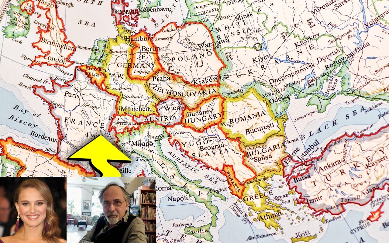
4. Building a Memory Palace: Turning Continents into Locations
A Memory Palace, also known as the method of loci, is a powerful mnemonic technique that involves mentally associating information with specific locations along a familiar route. You can turn continents into Memory Palaces to memorize countries, regions, and cities.
4.1. Choosing Your Memory Palace Route
Select a familiar location, such as your house, school, or commute. This will be your mental route.
4.2. Creating Mental Columns
Imagine a mental column running through the continent. For example, start in southern Portugal and travel north through Spain, France, and England.
4.3. Using Bridging Figures
Connect countries with “Bridging Figures” – people or objects that link the borders. These figures should be memorable and alphabetically coded to the countries.
- Portugal-Spain: Natalie Portman meeting Art Spiegelman at the border. (Portman for Portugal, Sp for Spiegelman/Spain)
- Spain-France: Art Spiegelman meeting Frankenstein at the border. (Sp for Spiegelman/Spain, Fr for Frankenstein/France)
- France-England: Frankenstein meeting Queen Elizabeth at the English Channel. (Fr for Frankenstein/France, En for England)
4.4. Adding Details and Specificity
The more details you add to your Memory Palace, the more effective it will be. Think about specific landmarks, cultural associations, or historical events related to each location.
5. Memorizing States, Regions, and Cities
Once you’ve mastered continents and countries, you can apply the same techniques to smaller regions. Australia, being both a continent and a country, provides a useful example.
5.1. Applying Associations to Regions
Imagine a drummer (perhaps Rob Hirst from Midnight Oil) moving clockwise around Australia, creating associations for each state:
- Western Australia: The drummer singing “Go West.”
- Northern Territory: The drummer dressed as Santa Claus.
- Queensland: The drummer dressed as Queen Elizabeth.
- South Australia: The drummer drinking South American wine
5.2. Scaling Down to Cities and Streets
Memorizing city maps requires more associations. Use the Major Method for street numbers and create detailed mental images for landmarks and intersections.
6. The Major Method: Mastering Street Numbers
The Major Method is a mnemonic system for converting numbers into consonant sounds, which can then be used to create memorable words or phrases. This is particularly useful for memorizing street numbers and addresses.
6.1. Assigning Sounds to Numbers
- 0: s, z
- 1: t, d
- 2: n
- 3: m
- 4: r
- 5: l
- 6: ch, sh, j
- 7: k, g
- 8: f, v
- 9: p, b
6.2. Forming Words and Phrases
Use these sounds to create words or phrases that are easy to visualize. For example, the number 12 might be represented by “tin,” and 35 by “mail.”
6.3. Applying to Addresses
For the address 123 Education Way, Learnville, CA 90210, you might create the following associations:
- 123: “Tom” (1=t, 2=n, 3=m)
- Education Way: Picture a dog kissing the road (Education Way).
- Learnville: Connect the education way and turn the Learnville into a village of learning
- 90210: “Bus, Nose, Sun” (9=b, 0=s, 2=n, 1=s, 0=s)
Imagine Tom the dog with a large bus with a broken nose driving through Education Way in Learnville, followed by the sun.
7. Consistent Practice and Recall
Memory techniques are powerful, but they require consistent practice and recall to transfer information into long-term memory.
7.1. Spaced Repetition
Use spaced repetition to review the information at increasing intervals. This helps to reinforce the memory over time. Apps like Anki can be helpful for this.
7.2. Creating a Recall Plan
Develop a personalized recall plan based on the complexity of the information and your learning style. There’s no one-size-fits-all approach.
7.3. Making it Fun
Learning maps should be an enjoyable experience. Incorporate games, quizzes, and interactive tools to make the process more engaging.
8. Utilizing Technology and Resources
There are numerous online resources and tools available to help you learn maps effectively.
8.1. Online Map Games and Quizzes
Websites like Seterra and Lizard Point offer interactive map games and quizzes that can help you test your knowledge and improve your recall.
8.2. Geographic Information Systems (GIS)
GIS software like QGIS can be used to explore and analyze geographic data, providing a deeper understanding of spatial relationships.
8.3. Educational Apps
Apps like Google Earth and National Geographic World Atlas provide detailed maps and information about countries, regions, and cities.
9. Real-World Applications and Benefits
The ability to learn and remember maps has practical applications in various fields and everyday life.
9.1. Travel and Navigation
Understanding maps makes travel more enjoyable and efficient. You’ll be able to navigate new cities with ease and appreciate the geographical context of the places you visit.
9.2. International Business and Diplomacy
Professionals in international business and diplomacy need a solid understanding of global geography to make informed decisions and negotiate effectively.
9.3. Environmental Science and Urban Planning
Environmental scientists and urban planners use maps to analyze spatial data, model environmental processes, and plan sustainable communities.
9.4. Personal Enrichment
Learning maps can be a rewarding hobby that expands your knowledge of the world and improves your cognitive skills.
10. Advanced Techniques for Map Mastery
Beyond the basics, several advanced techniques can further enhance your ability to learn and retain map information. These methods focus on deepening your understanding and making connections between geographical data and other knowledge domains.
10.1. Thematic Mapping
Thematic mapping involves visualizing specific data sets on a map to reveal patterns and relationships. For example, you might create a thematic map showing population density, climate zones, or economic indicators. This approach can help you understand the factors that shape different regions and countries.
Examples of Thematic Maps
| Type of Thematic Map | Description |
|---|---|
| Choropleth Map | Uses different colors or shading to represent statistical data within predefined areas (e.g., countries, states). Useful for showing data like population density or income levels. |
| Isopleth Map | Connects points of equal value to create continuous lines (isolines). Commonly used for showing temperature, elevation, or precipitation patterns. |
| Dot Density Map | Uses dots to represent the occurrence of a phenomenon. Effective for visualizing population distribution or agricultural production. |
| Proportional Symbol Map | Uses symbols (e.g., circles, squares) of varying sizes to represent the magnitude of a variable at different locations. Useful for comparing data like city populations or resource reserves. |
10.2. Historical Cartography
Studying historical maps can provide valuable insights into how geographical knowledge has evolved over time. By comparing maps from different periods, you can understand how borders have changed, how cities have grown, and how human activities have shaped the landscape.
Resources for Historical Maps
| Resource | Description |
|---|---|
| David Rumsey Map Collection | An extensive online collection of historical maps, ranging from the 16th to the 21st centuries. Offers high-resolution images and detailed descriptions. |
| Library of Congress Geography and Map Division | Holds one of the world’s largest and most comprehensive cartographic collections. Includes maps, atlases, globes, and other cartographic materials. |
| British Library Maps Website | Provides access to a wide range of historical maps, including thematic maps, military maps, and city plans. Offers digitized images and contextual information. |
| National Archives (UK) | Contains a wealth of historical maps related to British history, including Ordnance Survey maps, estate maps, and military plans. |
| Perry-Castañeda Library Map Collection | A large collection of maps covering various regions and time periods. Includes historical maps, contemporary maps, and thematic maps. |
10.3. Geographic Storytelling
Geographic storytelling involves using maps to tell narratives about people, places, and events. This approach can help you connect with geographical information on a deeper level and remember it more effectively.
Examples of Geographic Storytelling
- Historical Events: Create a map-based narrative of World War II, showing troop movements, major battles, and changing borders.
- Migration Patterns: Tell the story of human migration throughout history, highlighting the routes, causes, and impacts of major migrations.
- Environmental Changes: Use maps to illustrate the effects of climate change on different regions, showing rising sea levels, deforestation, and desertification.
- Cultural Diffusion: Map the spread of cultural traits (e.g., languages, religions, technologies) across different regions, showing how they have evolved and influenced local cultures.
- Economic Development: Visualize the economic growth and development of different countries, showing the distribution of industries, trade routes, and infrastructure.
10.4. Virtual Reality (VR) and Augmented Reality (AR)
VR and AR technologies offer immersive ways to experience maps and geographical information. VR allows you to explore virtual environments, while AR overlays digital information onto the real world. These technologies can make learning maps more engaging and interactive.
VR and AR Applications for Learning Maps
- Virtual Tours: Take virtual tours of historical sites, cities, and natural landscapes, learning about their geography and history in an immersive way.
- Interactive Maps: Use AR apps to overlay information about landmarks, buildings, and other features onto real-world maps.
- Geographic Games: Play VR or AR games that require you to navigate and explore virtual environments, testing your knowledge of geography and map reading skills.
- 3D Models: Explore 3D models of geographical features, such as mountains, rivers, and canyons, gaining a better understanding of their shape and structure.
- Educational Simulations: Use VR or AR simulations to learn about environmental processes, such as erosion, plate tectonics, and climate change, in an interactive way.
11. Integrating Learning Maps into Your Daily Life
To truly master the art of learning maps, it’s essential to integrate it into your daily routine. This involves making a conscious effort to engage with geographical information in various contexts.
11.1. News and Current Events
Pay attention to the locations mentioned in news articles and current events. Use maps to visualize the places and understand their geographical context. This will help you connect global events to specific locations and remember them more effectively.
Tips for Integrating Geography into News Consumption
| Tip | Description |
|---|---|
| Keep a World Map Handy | Have a physical or digital world map nearby when you read or watch the news. Refer to it whenever a new location is mentioned to visualize its geographical context. |
| Use Online Mapping Tools | Utilize online mapping tools like Google Maps or Google Earth to explore the locations featured in news stories. Zoom in to see details and understand the surrounding environment. |
| Create a News-Related Map Journal | Keep a journal where you record the locations mentioned in the news along with brief notes about their significance. Over time, this will create a personalized map of global events. |
| Follow Geographic News Sources | Subscribe to news sources that focus on geographic issues, such as National Geographic or The Geographical Magazine. These sources provide in-depth coverage of environmental, cultural, and political issues from a geographical perspective. |
| Participate in Online Discussions | Join online forums or social media groups dedicated to geography and current events. Share your insights and learn from others about the geographical dimensions of news stories. |
| Attend Lectures and Workshops | Attend lectures and workshops on geography and current events to deepen your understanding of the world. Many universities and educational institutions offer free or low-cost programs on these topics. |
| Travel When Possible | Whenever possible, travel to the locations featured in the news to experience them firsthand. This will provide you with a deeper understanding of their geography, culture, and history. |
11.2. Reading and Literature
When reading books or articles, pay attention to the settings and geographical details. Use maps to visualize the places and understand their significance in the story. This can enhance your understanding of the narrative and make it more memorable.
How Geography Enriches Reading Experiences
| Aspect of Reading | How Geography Enhances It |
|---|---|
| Understanding Setting | Knowing the geography of a book’s setting can help you visualize the environment and understand its influence on the characters and plot. For example, understanding the climate and terrain of the Amazon rainforest can enrich your reading of a novel set there. |
| Appreciating Cultural Context | Geography can provide insights into the cultural practices, traditions, and beliefs of the people in a book. For example, understanding the geography of Japan can enhance your appreciation of Japanese literature and art. |
| Connecting to Historical Events | Geography can help you understand the historical events and conflicts that shape a book’s narrative. For example, knowing the geography of Europe during World War I can enrich your understanding of a historical novel set in that period. |
| Visualizing Journeys and Quests | Following the geographical journeys of characters in a book can make their quests and adventures more vivid and engaging. For example, tracking the travels of Odysseus in Homer’s “Odyssey” can enhance your understanding of the epic poem. |
| Discovering New Worlds | Reading about unfamiliar places can spark your curiosity and inspire you to learn more about the world. For example, reading about the geography of Antarctica can motivate you to research its unique ecosystem and climate. |
11.3. Movies and Television
When watching movies or television shows, pay attention to the locations where the action takes place. Use maps to visualize the places and understand their geographical context. This can enhance your appreciation of the film and make it more memorable.
Tips for Using Movies and TV to Learn Geography
| Tip | Description |
|---|---|
| Identify the Setting | Pay attention to the locations where the movie or TV show is set. Note the country, region, city, and specific landmarks that are featured. |
| Use Online Mapping Tools | Use online mapping tools like Google Maps or Google Earth to explore the locations featured in the movie or TV show. Zoom in to see details and understand the surrounding environment. |
| Research the Geographical Context | Research the geographical context of the setting. Learn about its climate, terrain, natural resources, and cultural characteristics. This will help you understand how the environment influences the characters and plot. |
| Compare Fictional and Real-World Settings | If the movie or TV show is set in a fictional location, compare it to real-world settings that share similar characteristics. This will help you understand the geographical concepts and principles that are being illustrated. |
| Watch Documentaries and Travel Shows | Watch documentaries and travel shows that focus on different regions of the world. These programs can provide you with a wealth of information about geography, culture, and history. |
| Create a Movie/TV-Related Map Journal | Keep a journal where you record the locations featured in movies and TV shows along with brief notes about their significance. Over time, this will create a personalized map of cinematic geography. |
| Travel to Filming Locations | If possible, travel to the locations where movies or TV shows were filmed. This will provide you with a firsthand experience of the setting and enhance your appreciation of the film. |
11.4. Daily Commute
Use your daily commute as an opportunity to learn about the geography of your local area. Pay attention to the names of streets, neighborhoods, and landmarks. Use maps to explore the history and geography of your community.
Ways to Explore Local Geography During Your Commute
| Method | Description |
|---|---|
| Observe Street Names and Landmarks | Pay attention to the names of streets, parks, buildings, and other landmarks you pass during your commute. Research their origins and historical significance to learn about the history of your community. |
| Use a GPS Navigation App | Use a GPS navigation app like Google Maps or Waze to track your route and explore the surrounding area. Zoom in to see details and discover hidden gems. |
| Listen to Local History Podcasts | Listen to podcasts that focus on the history and geography of your local area. These podcasts can provide you with insights into the cultural, environmental, and economic factors that have shaped your community. |
| Read Local History Books and Articles | Read books and articles about the history and geography of your local area. These resources can provide you with a deeper understanding of the people, places, and events that have shaped your community. |
| Visit Local Museums and Historical Sites | Visit local museums and historical sites to learn about the history and geography of your community. These institutions often offer exhibits, tours, and educational programs that can enhance your understanding of the local area. |
| Take a Guided Walking or Biking Tour | Take a guided walking or biking tour of your local area. These tours can provide you with insights into the architecture, culture, and history of your community. |
| Create Your Own Commute-Related Map Journal | Keep a journal where you record the geographical features and historical landmarks you encounter during your commute along with brief notes about their significance. Over time, this will create a personalized map of your daily journey. |
12. Resources Available at LEARNS.EDU.VN
LEARNS.EDU.VN offers a variety of resources to help you learn maps effectively.
12.1. Articles and Tutorials
Access detailed articles and tutorials on mnemonic techniques, Memory Palace construction, and map memorization strategies.
12.2. Interactive Quizzes and Games
Test your knowledge and improve your recall with interactive quizzes and games.
12.3. Expert Guidance
Connect with experienced educators and geographers who can provide personalized guidance and support.
12.4. Structured Courses
Enroll in structured courses that cover various aspects of map learning, from basic geography to advanced spatial analysis.
13. Conclusion: Embark on Your Map Learning Journey
Learning maps is a rewarding journey that enhances your cognitive skills, expands your knowledge of the world, and provides practical benefits in various fields. By using mnemonic techniques, building Memory Palaces, and utilizing the resources available at LEARNS.EDU.VN, you can master the art of map learning and unlock a deeper understanding of our planet.
Ready to enhance your geographical knowledge? Visit LEARNS.EDU.VN today for comprehensive resources, expert guidance, and structured courses to master the art of map learning. For more information, contact us at 123 Education Way, Learnville, CA 90210, United States, Whatsapp: +1 555-555-1212, or visit our website at LEARNS.EDU.VN. Unlock your potential and start your journey towards geographical expertise!
FAQ: Frequently Asked Questions About Learning Maps
1. What are the best mnemonic techniques for learning maps?
Number rhymes, the Major Method, and the Memory Palace technique are highly effective.
2. How can I create a Memory Palace for map learning?
Choose a familiar location, identify distinct landmarks along a route, and associate each landmark with a specific geographical feature.
3. How often should I practice to effectively memorize maps?
Use spaced repetition and create a personalized recall plan to review the information at increasing intervals.
4. What online resources can help me learn maps?
Websites like Seterra and Lizard Point offer interactive map games and quizzes.
5. How can I integrate map learning into my daily life?
Pay attention to the locations mentioned in news, books, movies, and during your commute.
6. What are the benefits of learning maps?
Improved spatial reasoning, enhanced memory, deeper understanding of global events, and cultural awareness.
7. Is it possible to learn maps quickly?
Yes, with consistent practice and effective mnemonic techniques, you can make significant progress in a short amount of time.
8. What if I have difficulty visualizing maps?
Start with simple maps and gradually increase the complexity. Use physical maps and online tools to aid visualization.
9. Can learning maps help with other subjects?
Yes, the memory techniques used for map learning can be applied to other subjects like history, science, and languages.
10. How can LEARNS.EDU.VN help me learn maps?
learns.edu.vn offers detailed articles, interactive quizzes, expert guidance, and structured courses to help you master map learning.